| Date: June 22-23, 2013 | Sponsor: DDRC | |
| River: Trinity - Main Stem | Trip Leader: Libby Stovall | |
| Reach: 9.1 miles | Phone: 972-394-1170 home, 214-458-3418 | |
| Difficulty: Flatwater * (See scale below) | E-mail: Libbi Stovall | |
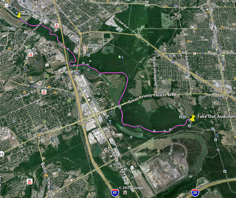
| Rendezvous: Standing Wave Park, 8th near Corinth | Required Skills: Basic winter flatwater paddling and camping experience | |
| Campground: Camping on island a little over 3 miles below the put-in. | Confirmation Deadline: June 20th |
TRIP DESCRIPTION:We will be paddling the Trinity River from the Trinity Wave Park in Oak Cliff and camping at the Audubon Center We are looking for a group of at least 10 for this trip. Camping is $15. If we don’t get 10 people, we can either each make up the amount for the members we lack or we will have to call off the trip. We will share the cost of the group breakfast – dinner is a potluck. There are tent pads, a campfire ring and lantern poles there now. We will have access to the entire park and half the building (the part with the restrooms). It is quite a hike from where we take out to the parking area, but we will have a couple of canoe carts for people to take turns hauling there canoes to there vehicles (between 1/3 & 1/2 mile). Note, it is hot in June, so be prepared. Unfortunately, we cannot allow dogs on the trip. We will put in at the Dallas Trinity Wave Park we put in below the whitewater and there is no whitewater on this section. It is a 4 to 5 hour paddle. I would prefer that we all stay together as a group, but if there is a group of speed demons, I will arrange for them to have a group leader. This is a Class I river, which means that is easy and has some fast moving water with riffles and small waves. There are few obstructions, all obvious and easily missed with little training. The risk to swimmers is slight (with the exception of the Eco-coli – so if you dump over, keep your mouth closed) and self-rescue is easy. DRIVING DIRECTIONS TO THE PUT IN: The wave park where we put in is South of Corinth Street on 8th Street. The little road that leads down to the river has a name now - Santa Fe Trail. It is just across from the light rail station. Santa Fe trail goes east from 8th behind the Bishop International Company. Follow it down to the river. We will shuttle the vehicles to the Trinity Audubon Center before we launch.THE RIVER: runs from the south west corner of town (Oak Cliff) south and East. When you paddle away from the Wave Park, you can still see Down Town Dallas. From the Wave Park to I-45, you can't see beyond the steep banks, but there is a lot of blighted businesses and housing that the City will be tearing down to create wetlands. Once under I-45, you are in the Great Trinity Forest - the largest Urban Forest in the US.IN THE FOREST: We will see rock shelves that reveal layers of muscle shells - this is an indication that Native Americans lived here and ate these delicacies. We will pass a cement turn style where steam ships that came up the Trinity from the Gulf, turned around. Once at camp, we can hike down to the lock and dam that was used to raise the river level so those ships could make it up to the turn style. These operations did not go on long, before they realized that it was not cost effective. Railroad beat out the steam ships for transportation to Dallas. You can hike along the Santa Fe Trestle above the Wave Park that they have converted into a foot-bridge that leads toward the area around the old Sears Building. We will also pass under two other active train trestles during our paddle. I believe that one of them will be torn down as part of the Trinity Corridor project as it is in the flood plain.
|
|
| * International Scale of River Difficulty
Class I: Easy. Fast moving water with riffles and small waves. Few obstructions, all obvious and easily missed with little training. Risk to swimmers is slight, self-rescue is easy.
Class II: Novice. Straightforward rapids with wide, clear channels which are evident without scouting. Occasional maneuvering may be required, but rocks and medium sized waves are easily missed by trained paddlers. Swimmers are seldom injured and group assistance, while helpful, is seldom needed. Class III: Intermediate. Rapids with moderate, irregular waves which may be difficult to avoid and which can swamp an open canoe. Complex maneuvers in fast current and good boat control in tight passages or around ledges are often required; large waves or strainers may be present but are easily avoided. Strong eddies and powerful current effects can be found, particularly on large-volume rivers. Scouting is advisable for inexperienced parties. Injuries while swimming are rare; self-rescue is usually easy but group assistance may be required to avoid long swims. Class IV: Advanced. Intense, powerful but predictable rapids requiring precise boat handling in turbulent water. Depending on the character of the river, it may feature large, unavoidable waves and holes or constricted passages demanding fast maneuvers under pressure. A fast, reliable eddy turn may be needed to initiate maneuvers, scout rapids, or rest. Rapids may require "must" moves above dangerous hazards. Scouting is necessary the first time down. Risk of injury to swimmers is moderate to high, and water conditions may make self-rescue difficult. Group assistance for rescue is often essential but requires practiced skills. A strong eskimo roll is highly recommended. Class V: Expert. Extremely long, obstructed, or very violent rapids which expose a paddler to above average endangerment. Drops may contain large, unavoidable waves and holes or steep, congested chutes with complex, demanding routes. Rapids may continue for long distances between pools, demanding a high level of fitness. What eddies exist may be small, turbulent, or difficult to reach. At the high end of the scale, several of these factors may be combined. Scouting is mandatory but often difficult. Swims are dangerous, and rescue is difficult even for experts. A very reliable eskimo roll, proper equipment, extensive experience, and practiced rescue skills are essential for survival. Class VI: Extreme. One grade more difficult than Class V. These runs often exemplify the extremes of difficulty, unpredictability and danger. The consequences of errors are very severe and rescue may be impossible. For teams of experts only, at favorable water levels, after close personal inspection and taking all precautions. This class does not represent drops thought to be unrunnable, but may include rapids which are only occasionally run. |
|
Copyright © 1996-2011, Dallas Downriver Club. All rights reserved.
You may not copy, distribute, or use these materials except for your personal, non-commercial use. Any trademarks are the property of their respective owners. All original photographic images are the exclusive property of Dallas Downriver Club or other designated photographers and may not be copied, duplicated, reproduced, distributed or used in any manner without prior written permission of the copyright owner under penalty of US and International laws and treaties. |