
San Marcos River
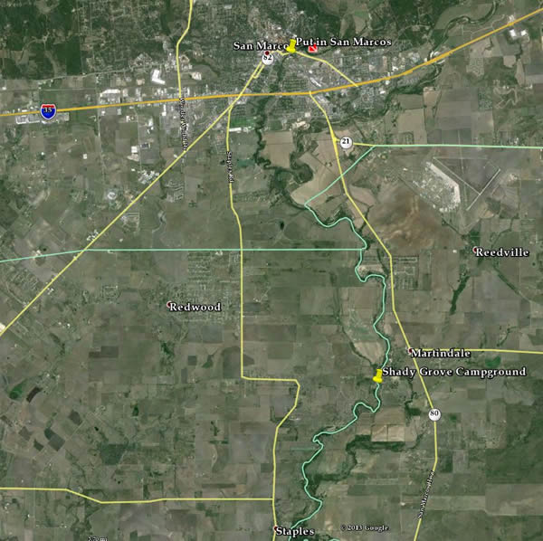
San Marcos to Shady Grove Camp Ground
| Date: August 30th - Sept 2nd | Sponsor: DDRC | |
| River: San Marcos | Trip Leader: Ken Liedtke | |
| Reach: TBD by water levels | Phone: 972-672-7979 | |
| Difficulty: Class I,II * (See scale below) | E-mail: klidkey@gmail.com | |
| Rendezvous: Shady Grove Campground | ||
| Campground: Shady Grove |
Trip Description:
Plans for San Marcos River Trip Labor Day Weekend 2013: Ken LiedtkeI’m leaving for San Marcos Friday for Labor Day Weekend in San Marcos and staying at Shady Grove campgrounds (512) 357-6113Here are my current plans if you’d like to join me.Saturday: Have Spencer Canoes shuttle us up to San Marcos City Park very early in the morning. Paddle from there back down to Shady Grove Park approximately 12 miles. Have all watercraft loaded up and ready to go the Friday night before so that we can go 1st thing in the morning. Trying to avoid the tubers. Eat a sack lunch on the river. Shuttle is about $5-30 pp depending on number of people.Those who want to, can drive into Austin Sat and/or Sunday night and watch the bats emerge from Congress Bridge. Stopping on the way there to eat supper.Sunday: option of paddling the same 12 miles as we did Saturday or the 5 miles below Shady Grove Park. Or if we get some good rain, drive over to the Guadalupe River. Use Jerry's Rentals or Gruene River Company to shuttle us up River Road a few crossings (4hr down). about $18 ppMonday: pack up, drive over to Rio Vista, surf a few standing waves then
|
 |
| * International Scale of River Difficulty
Class I: Easy. Fast moving water with riffles and small waves. Few obstructions, all obvious and easily missed with little training. Risk to swimmers is slight, self-rescue is easy.
Class II: Novice. Straightforward rapids with wide, clear channels which are evident without scouting. Occasional maneuvering may be required, but rocks and medium sized waves are easily missed by trained paddlers. Swimmers are seldom injured and group assistance, while helpful, is seldom needed. Class III: Intermediate. Rapids with moderate, irregular waves which may be difficult to avoid and which can swamp an open canoe. Complex maneuvers in fast current and good boat control in tight passages or around ledges are often required; large waves or strainers may be present but are easily avoided. Strong eddies and powerful current effects can be found, particularly on large-volume rivers. Scouting is advisable for inexperienced parties. Injuries while swimming are rare; self-rescue is usually easy but group assistance may be required to avoid long swims. Class IV: Advanced. Intense, powerful but predictable rapids requiring precise boat handling in turbulent water. Depending on the character of the river, it may feature large, unavoidable waves and holes or constricted passages demanding fast maneuvers under pressure. A fast, reliable eddy turn may be needed to initiate maneuvers, scout rapids, or rest. Rapids may require "must" moves above dangerous hazards. Scouting is necessary the first time down. Risk of injury to swimmers is moderate to high, and water conditions may make self-rescue difficult. Group assistance for rescue is often essential but requires practiced skills. A strong eskimo roll is highly recommended. Class V: Expert. Extremely long, obstructed, or very violent rapids which expose a paddler to above average endangerment. Drops may contain large, unavoidable waves and holes or steep, congested chutes with complex, demanding routes. Rapids may continue for long distances between pools, demanding a high level of fitness. What eddies exist may be small, turbulent, or difficult to reach. At the high end of the scale, several of these factors may be combined. Scouting is mandatory but often difficult. Swims are dangerous, and rescue is difficult even for experts. A very reliable eskimo roll, proper equipment, extensive experience, and practiced rescue skills are essential for survival. Class VI: Extreme. One grade more difficult than Class V. These runs often exemplify the extremes of difficulty, unpredictability and danger. The consequences of errors are very severe and rescue may be impossible. For teams of experts only, at favorable water levels, after close personal inspection and taking all precautions. This class does not represent drops thought to be unrunnable, but may include rapids which are only occasionally run. |
|
Copyright © 1996-2008, Dallas Downriver Club. All rights reserved. The textual, graphic, audio, and audio/visual material in this site is protected by United States copyright law and international treaties. You may not copy, distribute, or use these materials except for your personal, non-commercial use. Any trademarks are the property of their respective owners. All original photographic images are the exclusive property of Dallas Downriver Club or other designated photographers and may not be copied, duplicated, reproduced, distributed or used in any manner without prior written permission of the copyright owner. |