Buffalo National River, Arkansas
| Date: May 16-19, 2019 | Sponsor: DDRC |
| River: Buffalo National River | Trip Leader: Bryan Jackson |
| Reach: Tyler Bend to Rush 36 miles | Phone: 972-979-2519 |
| Difficulty: Whitewater Class I to II depending on flow * (See scale below) | E-mail: paddlinpals@yahoo.com |
| Rendezvous: Tyler Bend Camping Area | Required Skills: Moving water/Whitewater experience, proper protective gear, canoe camping |
| Campground: Canoe Camping "on the river' | RSVP Required before April 15, 2019 |
| Trip Description:
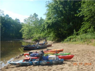
We will meet at Tyler Bend canoe launch area on Thursday morning at 9 am to stage boats and run the shuttle. The cost of the shuttle will be divided up among all participants. It is advisable that you come up the day before and spend the night at Tyler Bend as it takes quite a while to get up there. We will try to average about 10 miles per day Thursday through Saturday leaving a short paddle to our takeout on Sunday morning. Bring enough food and water for 4 days and 3 nights on the river. We will not do Pot Luck dinners on this trip, but some may choose to pool their resources and share meals. Notice!!!!
Bring your plastic boats. Do not bring fragile boats on this trip. We
have had boat breakage due to rocks in shallow spots two years in a row.
Last year one paddler had to come off the river on Day 1 due to a
cracked hull.
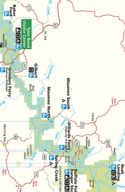
The Buffalo is Americas first National River, located in the heart of the southern Ozarks in northern Arkansas. This undammed, free-flowing clearwater river flows through a 135-mile corridor administered by the National Park Service and offers a real sense of wildness and isolation. You will float past towering multi-colored cliffs of limestone and sandstone that reach hundreds of feet above you. Dense forests line the banks, and hidden away in the flanking hollows are springs, caves, waterfalls, natural bridges and box canyons. There are prehistoric and historic cultural sites such as Archaic Indian bluff shelters or early settler cabins, some of which you can get to with a short hike. Most of the river consists of easy flatwater, but in some sections we may encounter Class I-II rapids. The river is not considered to be technically difficult, but it is recommended that paddlers have had some river running or canoe camping experience. We will run the reach from Ozark to US Highway 65, a distance of about 47 miles. Be Prepared! Weather in the Ozarks is changeable and we will be camping on gravel bars on the river away from the public access camping and launch areas. Be prepared for the possibility of rain or freezing weather at night and bring proper gear. This trip runs rain or shine, provided the river is not flooding. We will be hiring a shuttle to drop the drivers back at the put in and to drop one or more of our vehicles at the takeout on Sunday. Shuttle cost will be divided among the group.
Directions: From Dallas Take Interstate 30 to the west side of Little Rock, Ar. Take EXIT 129 to I-430 North Take EXIT 13B I-40 towards Fort Smith. Take EXIT 125 US 65 N toward US 65 B/Conway/Greenbrier/Harrison Keep right at the fork, follow signs for US 65 N and merge on to US 65 N Follow US 65 N for about 75 miles. the entrane to Tyler Bend will be on your left. If you cross the river, you went too far.
|
|
| * International Scale of River Difficulty
Class I: Easy. Fast moving water with riffles and small waves. Few obstructions, all obvious and easily missed with little training. Risk to swimmers is slight, self-rescue is easy.
Class II: Novice. Straightforward rapids with wide, clear channels which are evident without scouting. Occasional maneuvering may be required, but rocks and medium sized waves are easily missed by trained paddlers. Swimmers are seldom injured and group assistance, while helpful, is seldom needed. Class III: Intermediate. Rapids with moderate, irregular waves which may be difficult to avoid and which can swamp an open canoe. Complex maneuvers in fast current and good boat control in tight passages or around ledges are often required; large waves or strainers may be present but are easily avoided. Strong eddies and powerful current effects can be found, particularly on large-volume rivers. Scouting is advisable for inexperienced parties. Injuries while swimming are rare; self-rescue is usually easy but group assistance may be required to avoid long swims. Class IV: Advanced. Intense, powerful but predictable rapids requiring precise boat handling in turbulent water. Depending on the character of the river, it may feature large, unavoidable waves and holes or constricted passages demanding fast maneuvers under pressure. A fast, reliable eddy turn may be needed to initiate maneuvers, scout rapids, or rest. Rapids may require "must" moves above dangerous hazards. Scouting is necessary the first time down. Risk of injury to swimmers is moderate to high, and water conditions may make self-rescue difficult. Group assistance for rescue is often essential but requires practiced skills. A strong eskimo roll is highly recommended. Class V: Expert. Extremely long, obstructed, or very violent rapids which expose a paddler to above average endangerment. Drops may contain large, unavoidable waves and holes or steep, congested chutes with complex, demanding routes. Rapids may continue for long distances between pools, demanding a high level of fitness. What eddies exist may be small, turbulent, or difficult to reach. At the high end of the scale, several of these factors may be combined. Scouting is mandatory but often difficult. Swims are dangerous, and rescue is difficult even for experts. A very reliable eskimo roll, proper equipment, extensive experience, and practiced rescue skills are essential for survival. Class VI: Extreme. One grade more difficult than Class V. These runs often exemplify the extremes of difficulty, unpredictability and danger. The consequences of errors are very severe and rescue may be impossible. For teams of experts only, at favorable water levels, after close personal inspection and taking all precautions. This class does not represent drops thought to be unrunnable, but may include rapids which are only occasionally run. |
|
Copyright © 1996-2011, Dallas Downriver Club. All rights reserved.
You may not copy, distribute, or use these materials except for your personal, non-commercial use. Any trademarks are the property of their respective owners. All original photographic images are the exclusive property of Dallas Downriver Club or other designated photographers and may not be copied, duplicated, reproduced, distributed or used in any manner without prior written permission of the copyright owner under penalty of US and International laws and treaties.
last updated February 26, 2019 3:09 PM |