New Years on the Colorado River
| Date: December 30, 2016- January 1, 2017 | Sponsor: DDRC |
| River : Colorado River | Trip Leader: Dale Harris |
| Reach: Colorado River west of Austin, TX | Phone: 972-814-2633 |
| Difficulty: FLATWATER | E-mail: President@down-river.com |
| Rendezvous: Friday December 30, 5pm Colorado Bend State Park | Required Skills: Basic paddling Skills, proper protective gear, base camping |
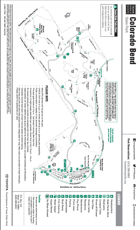
| Campground: Colorado Bend SP |
| Trip Description:
The New Year’s weekend trip is at Colorado Bend State Park, December 30th – January 1st. This a small park on the Colorado River west of Austin with lots of things to do. The park is closed until 2pm Friday December 30th – then it will open for the weekend. I plan on arriving Friday afternoon. We’ll have to watch the water levels to determine where to go paddling, we can also hike up to the local water falls.The campsites do not have RV hook ups so plan accordingly. There several places to get water. So bring your family and visiting & reminiscing while sitting around the camp fire.
Basic items; life jacket, canoe or kayak, water, sunscreen, lawn chairs, and light jacket for the evening. Meals: Saturday night we’ll have Pot Luck dinner and quietly celebrate New Year’s eve.
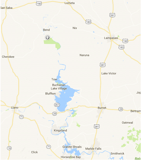
Directions:The park is west of Lampasas, southeast of San Saba. From the
intersection of U.S. Highways 281 and 183 in Lampasas, take FM 580 west 24
miles to Bend and follow the signs four miles to the park entrance. From
San Saba, take U.S. Highway 190 about four miles to FM 580 and follow the
signs 13 miles to Bend; follow the signs four miles to the park entrance
(two miles of dirt road). The headquarters and main camping are six miles
past the entrance on the dirt road (unmarked County Road 442). Access road
subject to flooding. Note: No gasoline service in
Bend. The Park HQ is located at: |
Click on Map for Full PDF
|
| * International Scale of River Difficulty
Class I: Easy. Fast moving water with riffles and small waves. Few obstructions, all obvious and easily missed with little training. Risk to swimmers is slight, self-rescue is easy.
Class II: Novice. Straightforward rapids with wide, clear channels which are evident without scouting. Occasional maneuvering may be required, but rocks and medium sized waves are easily missed by trained paddlers. Swimmers are seldom injured and group assistance, while helpful, is seldom needed. Class III: Intermediate. Rapids with moderate, irregular waves which may be difficult to avoid and which can swamp an open canoe. Complex maneuvers in fast current and good boat control in tight passages or around ledges are often required; large waves or strainers may be present but are easily avoided. Strong eddies and powerful current effects can be found, particularly on large-volume rivers. Scouting is advisable for inexperienced parties. Injuries while swimming are rare; self-rescue is usually easy but group assistance may be required to avoid long swims. Class IV: Advanced. Intense, powerful but predictable rapids requiring precise boat handling in turbulent water. Depending on the character of the river, it may feature large, unavoidable waves and holes or constricted passages demanding fast maneuvers under pressure. A fast, reliable eddy turn may be needed to initiate maneuvers, scout rapids, or rest. Rapids may require "must" moves above dangerous hazards. Scouting is necessary the first time down. Risk of injury to swimmers is moderate to high, and water conditions may make self-rescue difficult. Group assistance for rescue is often essential but requires practiced skills. A strong eskimo roll is highly recommended. Class V: Expert. Extremely long, obstructed, or very violent rapids which expose a paddler to above average endangerment. Drops may contain large, unavoidable waves and holes or steep, congested chutes with complex, demanding routes. Rapids may continue for long distances between pools, demanding a high level of fitness. What eddies exist may be small, turbulent, or difficult to reach. At the high end of the scale, several of these factors may be combined. Scouting is mandatory but often difficult. Swims are dangerous, and rescue is difficult even for experts. A very reliable eskimo roll, proper equipment, extensive experience, and practiced rescue skills are essential for survival. Class VI: Extreme. One grade more difficult than Class V. These runs often exemplify the extremes of difficulty, unpredictability and danger. The consequences of errors are very severe and rescue may be impossible. For teams of experts only, at favorable water levels, after close personal inspection and taking all precautions. This class does not represent drops thought to be unrunnable, but may include rapids which are only occasionally run. |
|
Copyright © 1996-2011, Dallas Downriver Club. All rights reserved.
You may not copy, distribute, or use these materials except for your personal, non-commercial use. Any trademarks are the property of their respective owners. All original photographic images are the exclusive property of Dallas Downriver Club or other designated photographers and may not be copied, duplicated, reproduced, distributed or used in any manner without prior written permission of the copyright owner under penalty of US and International laws and treaties. |