
| Date: February 20th-22nd, 2014 | Sponsor: DDRC |
| River: Middle Sabine - San Marcos | Trip Leader: Bryan Jackson |
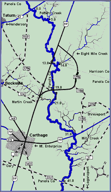
| Reach: US Highway 59 to FM 2517 | Phone: 972-979-2519 |
| Difficulty: Flatwater - no rapids * (See scale below) | E-mail: paddlinpals@yahoo.com |
Rendezvous: US Hwy 59 bridge near Carthage, 9:00 AM Friday San Marcos River Retreat |
|
| Campground: Riverside sandbar beaches | SEE BELOW and call Bryan if you need to change your planned attendance |

updated 02/18/2015
San Marcos River Retreat444 Pecan Park Dr, San Marcos, TX
Trip Description: DUE TO INCLEMENT WEATHER THE SABINE FISHING TRIP WILL BE MOVED TO THE SAN MARCOS RIVER..... We will now be base camping at San Marcos River Retreat and doing day paddles on Friday and Saturday. We will be fishing along the way so the pace will be relaxed. Plan is to meet at the campground on Friday morning, run a shuttle and do a section of the river on Friday, have a nice cozy evening by the campfire, then paddle on Saturday. If we are successful a fish fry will break out, otherwise, it will be beenie' weenie night (not).
Bring camping and eating gear and your boat, do not forget a fishing license if you plan to fish. For more info, call Bryan at 972-979-2519
We will be paddling the Middle Sabine River
between US Highway 59 just east of Carthage down to FM 2517 southeast of
Carthage. The total trip distance is 29 miles on flatwater with no hazards
other than mosquitoes, and it should be too early for those pests.
We
will meet at the US 59 bridge at 9am on Friday where
it crosses the Sabine River, north of Carthage. We will run a run a shuttle
and fish our way down the river, camping on sandy beaches each night. We will
camp near the FM 1794 crossing the first night so that any who are unable to
come for Friday can join us on Saturday morning. Please let us know in
advance if you plan to meet us on Saturday. We will be going
"light" on this trip, so everyone will be responsible for their own
food, although if the fishing is good, the chances of a fish feast breaking
out are likely.
This section of the Sabine is
beautiful and very scenic, though you may see an occasional motorboat with
one or more anglers aboard. The white bass are expected to be running during this trip. The river is rife with gorgeous, white sand
beaches where we can stop to fish, snack, eat or camp. Some of the beaches
are quite large, and most have shallow gradient landings for easy unloading
and loading, yet offer camping high enough to be above any unexpected river
rises should a heavy rain fall while we are there.
The Sabine River is an excellent
fishing stream where you can catch blue, yellow and channel catfish, small
mouth, yellow-belly, white and sand bass, drum, carp, crappie, gar and other
species. Bald eagles are sometimes seen flying above
the river. Otters, beavers and nutria may be seen if
you are quiet and look carefully. The most common "bird" is the
paddler-eating mosquito, so be prepared! Great blue herons, buzzards and
numerous species of songbirds will be seen. Due to
the remoteness of the area you may see snakes.
Common species include water moccasins, copperheads and several species of
non-venomous water snakes, but none are usually a
problem. This is a good place to bring a camera.
Please note that the reach we paddle may be changed due to weather, river flow conditions, fishing conditions or other factors that will be apparent closer to the trip date. Anybody interested in this trip should e-mail Bryan or RSVP on Meetup so that that a head count can be taken and appropriate planning can be done in advance of the trip date.
Gear Requirements: Bring boats (just about any seaworthy craft will do for this trip), PFD's (lifejackets), paddles (a spare is recommended), a whistle or other signalling device, throwbag, tent, ground pad, sleeping bag, clothing for hot, cold, wet and dry conditions, camp chair, headlamp, plate(s), flatware, drinking cup, personal toiletries and other items that you may want to have with you. A small cooler for drinks and lunches to be carried in your boat would be recommended. Bring everythng you need for two nights on the river. Fishing Licenses are recommended as the river is patrolled by TP&W this time of year and so are the river access points. Meals: Everyone will be responsible for their own food, although if the fishing is good the chances of a fish feast breaking out are likely. Bring plenty of beverages, but remember - NO GLASS OR FOAM POLYSTYRENE STYROFOAM CONTAINERS! Back-up Plans: There is no backup plan for this trip. If, for any reason, the trip on the Sabine cannot be made, then it will be cancelled. Driving Directions: This reach of the Sabine River is located in Panola County near the Louisiana border and just above Toledo Bend Reservoir. It is about 30 miles south of Marshall, just outside Carthage. From Dallas: IH 20 East to Marshall, then RIGHT (South) on US Highway 59; |
 |
| * International Scale of River Difficulty
Class I: Easy. Fast moving water with riffles and small waves. Few obstructions, all obvious and easily missed with little training. Risk to swimmers is slight, self-rescue is easy.
Class II: Novice. Straightforward rapids with wide, clear channels which are evident without scouting. Occasional maneuvering may be required, but rocks and medium sized waves are easily missed by trained paddlers. Swimmers are seldom injured and group assistance, while helpful, is seldom needed. Class III: Intermediate. Rapids with moderate, irregular waves which may be difficult to avoid and which can swamp an open canoe. Complex maneuvers in fast current and good boat control in tight passages or around ledges are often required; large waves or strainers may be present but are easily avoided. Strong eddies and powerful current effects can be found, particularly on large-volume rivers. Scouting is advisable for inexperienced parties. Injuries while swimming are rare; self-rescue is usually easy but group assistance may be required to avoid long swims. Class IV: Advanced. Intense, powerful but predictable rapids requiring precise boat handling in turbulent water. Depending on the character of the river, it may feature large, unavoidable waves and holes or constricted passages demanding fast maneuvers under pressure. A fast, reliable eddy turn may be needed to initiate maneuvers, scout rapids, or rest. Rapids may require "must" moves above dangerous hazards. Scouting is necessary the first time down. Risk of injury to swimmers is moderate to high, and water conditions may make self-rescue difficult. Group assistance for rescue is often essential but requires practiced skills. A strong eskimo roll is highly recommended. Class V: Expert. Extremely long, obstructed, or very violent rapids which expose a paddler to above average endangerment. Drops may contain large, unavoidable waves and holes or steep, congested chutes with complex, demanding routes. Rapids may continue for long distances between pools, demanding a high level of fitness. What eddies exist may be small, turbulent, or difficult to reach. At the high end of the scale, several of these factors may be combined. Scouting is mandatory but often difficult. Swims are dangerous, and rescue is difficult even for experts. A very reliable eskimo roll, proper equipment, extensive experience, and practiced rescue skills are essential for survival. Class VI: Extreme. One grade more difficult than Class V. These runs often exemplify the extremes of difficulty, unpredictability and danger. The consequences of errors are very severe and rescue may be impossible. For teams of experts only, at favorable water levels, after close personal inspection and taking all precautions. This class does not represent drops thought to be unrunnable, but may include rapids which are only occasionally run. |
|
Copyright © 1996-2011, Dallas Downriver Club. All rights reserved.
You may not copy, distribute, or use these materials except for your personal, non-commercial use. Any trademarks are the property of their respective owners. All original photographic images are the exclusive property of Dallas Downriver Club or other designated photographers and may not be copied, duplicated, reproduced, distributed or used in any manner without prior written permission of the copyright owner under penalty of US and International laws and treaties. |