
Thanksgiving Weekend
Kiamichi River
| Date: November 29-Dec 1, 2013 | Sponsor: DDRC | |
| River: Kiamichi near Antlers, OK | Trip Leader: Bryan Jackson | |
| Reach: TBD depending on water flow | Phone: 972-680-2727 | |
| Difficulty: Flatwater - no rapids * (See scale below) | E-mail: Treasurer@down-river.com | |
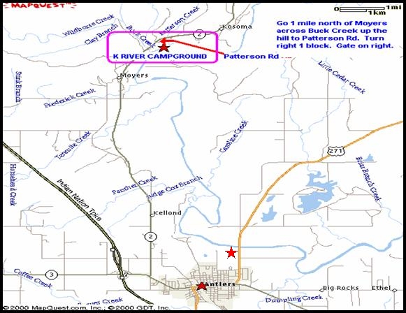
| Rendezvous: K-River Campground | ||
| Campground: K-River Campground |
| Trip Description:
Our
2012 Thanksgiving Trip returns to K-River Campground outside of Antlers,
Ok in Southeast Oklahoma. We will gather on Friday, have a paddle on
Saturday and maybe Sunday depending on the river flow and of course have
our traditional Thanksgiving potluck on Saturday evening. This is a great
on which to just relax, avoid the madness of Black Friday and enjoy the
company of friends.
Gear Requirements: Bring boats (just about any seaworthy craft will do for this trip), PFD's (lifejackets), paddles (a spare is recommended), a whistle or other signaling device, throwbag, etc. K-River does have canoes and kayaks available for rent. We will be base camping and K-River accommodates everything from pup tents to motor homes and has cabins available as well. Meals: Bring your own meals, and bring something for the Saturday night potluck dinner which will have a Thanksgiving theme and will feature a cajun fried turkey. Back-up Plans: There is no backup plan for this trip. Driving Directions: K River Campground is located in Pushmataha County, in southeastern Oklahoma just a few miles north of Antlers. GPS Coordinates are W 95 䓦'10" N34䓔'50"From Dallas (to K River Campground): US 75 (Central Expy.) North to Durant, then East on US Hwy 70 From Dallas (Alternate Route): IH 30 North/East to Commerce, then north on SH 24 |
 |
| * International Scale of River Difficulty
Class I: Easy. Fast moving water with riffles and small waves. Few obstructions, all obvious and easily missed with little training. Risk to swimmers is slight, self-rescue is easy.
Class II: Novice. Straightforward rapids with wide, clear channels which are evident without scouting. Occasional maneuvering may be required, but rocks and medium sized waves are easily missed by trained paddlers. Swimmers are seldom injured and group assistance, while helpful, is seldom needed. Class III: Intermediate. Rapids with moderate, irregular waves which may be difficult to avoid and which can swamp an open canoe. Complex maneuvers in fast current and good boat control in tight passages or around ledges are often required; large waves or strainers may be present but are easily avoided. Strong eddies and powerful current effects can be found, particularly on large-volume rivers. Scouting is advisable for inexperienced parties. Injuries while swimming are rare; self-rescue is usually easy but group assistance may be required to avoid long swims. Class IV: Advanced. Intense, powerful but predictable rapids requiring precise boat handling in turbulent water. Depending on the character of the river, it may feature large, unavoidable waves and holes or constricted passages demanding fast maneuvers under pressure. A fast, reliable eddy turn may be needed to initiate maneuvers, scout rapids, or rest. Rapids may require "must" moves above dangerous hazards. Scouting is necessary the first time down. Risk of injury to swimmers is moderate to high, and water conditions may make self-rescue difficult. Group assistance for rescue is often essential but requires practiced skills. A strong eskimo roll is highly recommended. Class V: Expert. Extremely long, obstructed, or very violent rapids which expose a paddler to above average endangerment. Drops may contain large, unavoidable waves and holes or steep, congested chutes with complex, demanding routes. Rapids may continue for long distances between pools, demanding a high level of fitness. What eddies exist may be small, turbulent, or difficult to reach. At the high end of the scale, several of these factors may be combined. Scouting is mandatory but often difficult. Swims are dangerous, and rescue is difficult even for experts. A very reliable eskimo roll, proper equipment, extensive experience, and practiced rescue skills are essential for survival. Class VI: Extreme. One grade more difficult than Class V. These runs often exemplify the extremes of difficulty, unpredictability and danger. The consequences of errors are very severe and rescue may be impossible. For teams of experts only, at favorable water levels, after close personal inspection and taking all precautions. This class does not represent drops thought to be unrunnable, but may include rapids which are only occasionally run. |
|
Copyright © 1996-2011, Dallas Downriver Club. All rights reserved.
. All original photographic images are the exclusive property of Dallas Downriver Club or other designated photographers and may not be copied, duplicated, reproduced, distributed or used in any manner without prior written permission of the copyright owner under penalty of US and International laws and treaties. |