 Weekend of Memorial Day
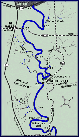
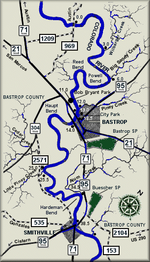
Colorado - Webberville to Bastrop
| Date: May 25th to 27th, 2013 | Sponsor: DDRC | |
| River: Colorado - Webberville to Bastrop Fishermen's Park | Trip Leader: Tom Taylor ..... | |
| Reach: Webberville to Bastrop | Phone: 214 335-5058 - Tom | |
| Difficulty: Flatwater - no rapids * (See scale below) | E-mail: tomtaylr@swbell.net | |
| Rendezvous: Little Webberville Park , 9:00 AM Saturday | ||
| Campground: Island sandbar beach |
| Trip Description:
The plan is to meet at Littler Webberville Park on Saturday morning, May 25. We will run our shuttle down to Fisherman's Park in Bastrop, then launch between 11 AM and 12 noon. It is imperative that everybody be at Little Webberville Park and have gear and boats unloaded as close to 10:00 AM as possible so that we can start the shuttle! We will camp on river islands Saturday and Sunday nights before arriving at Fisherman's Park late Monday morning. The Colorado River is a Class I flatwater stream with a few minor riffles. It is generally safe for almost anybody regardless of experience or skills. The islands available to us are large enough to accommodate a big group. Everybody is responsible for their own meals, but we will have a potluck dinner on Saturday night, so please bring something to share. We will have Neal Cook of Cook's Canoes shuttle us from Bastrop back to Webberville after we drop off vehicles at Fisherman's Park, and there will be a fee of $10.00 per driver for this trip to cover shuttle expenses - that amount will be shared by all group members equally. Only drivers need to make the shuttle run.
Put in Take OutDriving Directions: Go south on IH 35E through Waco to Austin; |
|
| * International Scale of River Difficulty
Class I: Easy. Fast moving water with riffles and small waves. Few obstructions, all obvious and easily missed with little training. Risk to swimmers is slight, self-rescue is easy.
Class II: Novice. Straightforward rapids with wide, clear channels which are evident without scouting. Occasional maneuvering may be required, but rocks and medium sized waves are easily missed by trained paddlers. Swimmers are seldom injured and group assistance, while helpful, is seldom needed. Class III: Intermediate. Rapids with moderate, irregular waves which may be difficult to avoid and which can swamp an open canoe. Complex maneuvers in fast current and good boat control in tight passages or around ledges are often required; large waves or strainers may be present but are easily avoided. Strong eddies and powerful current effects can be found, particularly on large-volume rivers. Scouting is advisable for inexperienced parties. Injuries while swimming are rare; self-rescue is usually easy but group assistance may be required to avoid long swims. Class IV: Advanced. Intense, powerful but predictable rapids requiring precise boat handling in turbulent water. Depending on the character of the river, it may feature large, unavoidable waves and holes or constricted passages demanding fast maneuvers under pressure. A fast, reliable eddy turn may be needed to initiate maneuvers, scout rapids, or rest. Rapids may require "must" moves above dangerous hazards. Scouting is necessary the first time down. Risk of injury to swimmers is moderate to high, and water conditions may make self-rescue difficult. Group assistance for rescue is often essential but requires practiced skills. A strong eskimo roll is highly recommended. Class V: Expert. Extremely long, obstructed, or very violent rapids which expose a paddler to above average endangerment. Drops may contain large, unavoidable waves and holes or steep, congested chutes with complex, demanding routes. Rapids may continue for long distances between pools, demanding a high level of fitness. What eddies exist may be small, turbulent, or difficult to reach. At the high end of the scale, several of these factors may be combined. Scouting is mandatory but often difficult. Swims are dangerous, and rescue is difficult even for experts. A very reliable eskimo roll, proper equipment, extensive experience, and practiced rescue skills are essential for survival. Class VI: Extreme. One grade more difficult than Class V. These runs often exemplify the extremes of difficulty, unpredictability and danger. The consequences of errors are very severe and rescue may be impossible. For teams of experts only, at favorable water levels, after close personal inspection and taking all precautions. This class does not represent drops thought to be unrunnable, but may include rapids which are only occasionally run. |
|
Copyright © 1996-2011, Dallas Downriver Club. All rights reserved.
. All original photographic images are the exclusive property of Dallas Downriver Club or other designated photographers and may not be copied, duplicated, reproduced, distributed or used in any manner without prior written permission of the copyright owner under penalty of US and International laws and treaties. |