
MEMORIAL DAY TRIP
Sabine River below Toledo Bend
| Date: May 26-28, 2012 | Sponsor: DDRC | |
| River: Sabine River | Trip Leader: Earl Atnip | |
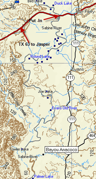
| Reach: TX63 at Burr Ferry to Bayou Anacoco | Phone: 214-882-0952 | |
| Difficulty: Flatwater - no rapids * (See scale below) | E-mail: e-atnip@ti.com | |
| Rendezvous: West Side of TX 63 bridge east of Jasper, TX , 9:00 AM Saturday | ||
| Campground: Island sandbar beachs |
| Trip Description:
This is a flatwater paddle down the Lower Sabine River in far
southeast Texas. Here the
river flows out of Toledo Bend Reservoir to the Gulf of Mexico. It travels through the thick piney woods that define the
Texas/Louisiana border. We
will rendezvous at LA hwy 8. I
will post additional driving directions once I discuss further with the
shuttle service. It is an
approximate 5 hr drive from Dallas so plan accordingly for a 9am meet up.
We will plan to be unloaded and drivers running vehicles downriver
by 10am. We will camp
Saturday and Sunday nights along the squeaky white sandy shoals that line
the banks. The take out is
just downstream from Anacoco Bayou, sometime Monday.
Exact details on this to follow once I get them from the shuttle
service. We will be using
Tackapaw shuttle service Tackapaw.com
. Shuttle cost will also be added later. This
section of river is a Class I flatwater stream. It is generally safe for almost anybody regardless of
experience or skills. Everybody is responsible for their own meals. Gear Requirements: Bring boats (just about any seaworthy craft will do for this trip), PFD's (lifejackets), paddles (a spare is recommended), a whistle or other signalling device, throwbag, tent, ground pad, sleeping bag, clothing for hot, cold, wet and dry conditions, camp chair, headlamp, plate(s), flatware, drinking cup, personal toiletries and other items that you may want to have with you. A small cooler for drinks and lunches to be carried in your boat would be recommended. Members of the group should coordinate on community gear such as cookware, stoves, fuel, charcoal and other such items. Meals: Bring your own meals, and bring something for the Saturday night potluck dinner, a group meal with no specific theme. Bring plenty of beverages, but remember - NO GLASS OR FOAM POLYSTYRENE STYROFOAM CONTAINERS! Back-up Plans: There is no backup plan for this trip. WATCH THE WEBSITE AND YOUR E-MAIL WITHIN THE WEEK LEADING UP TO THE TRIP FOR LAST MINUTE DETAILS AND CHANGES OF PLANS. Driving Directions: From Dallas via US 175 & US 69: Follow US 175 east from Dallas to Jacksonville and the junction with US 69 south. Turn right (south) on to US 69. Follow US 69 south to Zavalla, Turn Left on TX 63 east towards Jasper. Follow TX 63 through the towns of Jasper and Burkeville to the Sabine River. Unloading area is on the right before you go over the bridge. From Dallas via I 20 and US 96S: Follow I 20 east to exit 595A (TX 322 S/Estes Pkwy). Turn Right on S Estes Pkwy and continue to TX-149E. Turn right onto TX-149E /US 79S follow to US 59S. Turn Right on US 59 S then bear on to US 96S when 59 and 96 split south of Carthage. Follow TX96 to Jasper. Turn Right on TX 63 and follow TX 63 through the towns of Jasper and Burkeville to the Sabine River. Unloading area is on the right before you go over the bridge.
|
 |
| * International Scale of River Difficulty
Class I: Easy. Fast moving water with riffles and small waves. Few obstructions, all obvious and easily missed with little training. Risk to swimmers is slight, self-rescue is easy.
Class II: Novice. Straightforward rapids with wide, clear channels which are evident without scouting. Occasional maneuvering may be required, but rocks and medium sized waves are easily missed by trained paddlers. Swimmers are seldom injured and group assistance, while helpful, is seldom needed. Class III: Intermediate. Rapids with moderate, irregular waves which may be difficult to avoid and which can swamp an open canoe. Complex maneuvers in fast current and good boat control in tight passages or around ledges are often required; large waves or strainers may be present but are easily avoided. Strong eddies and powerful current effects can be found, particularly on large-volume rivers. Scouting is advisable for inexperienced parties. Injuries while swimming are rare; self-rescue is usually easy but group assistance may be required to avoid long swims. Class IV: Advanced. Intense, powerful but predictable rapids requiring precise boat handling in turbulent water. Depending on the character of the river, it may feature large, unavoidable waves and holes or constricted passages demanding fast maneuvers under pressure. A fast, reliable eddy turn may be needed to initiate maneuvers, scout rapids, or rest. Rapids may require "must" moves above dangerous hazards. Scouting is necessary the first time down. Risk of injury to swimmers is moderate to high, and water conditions may make self-rescue difficult. Group assistance for rescue is often essential but requires practiced skills. A strong eskimo roll is highly recommended. Class V: Expert. Extremely long, obstructed, or very violent rapids which expose a paddler to above average endangerment. Drops may contain large, unavoidable waves and holes or steep, congested chutes with complex, demanding routes. Rapids may continue for long distances between pools, demanding a high level of fitness. What eddies exist may be small, turbulent, or difficult to reach. At the high end of the scale, several of these factors may be combined. Scouting is mandatory but often difficult. Swims are dangerous, and rescue is difficult even for experts. A very reliable eskimo roll, proper equipment, extensive experience, and practiced rescue skills are essential for survival. Class VI: Extreme. One grade more difficult than Class V. These runs often exemplify the extremes of difficulty, unpredictability and danger. The consequences of errors are very severe and rescue may be impossible. For teams of experts only, at favorable water levels, after close personal inspection and taking all precautions. This class does not represent drops thought to be unrunnable, but may include rapids which are only occasionally run. |
|
Copyright © 1996-2011, Dallas Downriver Club. All rights reserved.
. All original photographic images are the exclusive property of Dallas Downriver Club or other designated photographers and may not be copied, duplicated, reproduced, distributed or used in any manner without prior written permission of the copyright owner under penalty of US and International laws and treaties. |