
| Date: December 26, 2010 | Sponsor: DDRC | |
| River: Upper Sabine | Trip Leader: Bryan Jackson | |
| Reach: US Highway 69 Local | Phone: 972-979-2519 | |
| Difficulty: Flatwater - no rapids * (See scale below) | E-mail: hollowcreek@paddlinpals.com | |
| Rendezvous: US Hwy 69 bridge between Mineola and Lindale, 11:00 AM Sunday | ||
| Campground: N/A |
| Trip Description:
This will be a partial reprise of our infamous Upper Sabine River trip of December 26, 2005, and if you are not familiar with this now legendary trip, then you can read the report about it HERE! The short version is that we did an afternoon trip that turned into an overnight trip in winter without the benefit of warm clothing, tents, sleeping bags, extra food, extra beverages, headlamps (Tom was the ONLY one of sever who brought one), or almost anything else that would normally be necessary for a mid-winter overnight river trip. This time, knowing what we do from past experience, we will NOT be going all the way down to FM 1104 because we have already been there and done that. "Fool me once, shame on you. Fool me twice - you can't get fooled again." (Some litereary scholar once made that statement.) This time, it will be different. We plan on paddling down to the first of the log jams we encountered (hopefully, there will be no new ones to portage before getting to the one that started our misery), eat lunch, and then paddle back to the bridge at the put-in where we will take out and live to laugh about the trip we made 5 years ago that is still the subject of a lot of derision and sick humor. Our "Gilligan" will be the same one who led the ill-fated fiasco in 2005 - Bryan Jackson who, having the benefit of hindsight, promises that we will end this trip the same day as we start it, and be back home before dark. For those who want to duplicate the entire 2005 trip, we will arrange to pick you up the following day... or two, or three... Come join us for an adventure that, hopefully, will not displace the original 3-Hour Tour in the lore of historical DDRC trips. Bring your boat (this is a flatwater trip, but bring a lightweight one just in case we do encounter more downed trees), PFD, paddle, appropriate clothing for the then-current weather conditions, and you might want to bring extra (warm) clothing, tents, sleeping bags, extra food and beverages and anything else you might want or need for an overnight trip in the event that we duplicate more than just the start of that previous trip. Be sure to include a headlamp, extra batteries, Mr. Heater and three or four propane bottles just in case Bryan gets us lost again. All seriousness aside, do bring warm clothing (just in case the weather turns cold on us) and some additional food and drinks. You can actually leave the tents, sleeping bags, etc. at home. We REALLY do NOT expect to be on this trip overnight! But, some apple cider mix, water and a drinking cup to fight hypothermia is seriously recommended. We will, undoubtedly, have a couple of propane stoves and some fuel in the event anybody gets chilled to the bone. Gear Requirements: Bring boats (just about any seaworthy craft will do for this trip), PFD's (lifejackets), paddles (a spare is recommended), a whistle or other signalling device, appropriate clothing for the conditions we expect to encounter, headlamp, food, beverages, drinking cup and a mylar space blanket, as well as a warm, dry set of clothes just in case. A small cooler for drinks and lunches to be carried in your boat would be recommended. Meals: Bring whatever you want to eat and drink for lunch, but remember - NO GLASS OR FOAM POLYSTYRENE STYROFOAM CONTAINERS! Back-up Plans: There is no backup plan for this trip. If, for any reason, the trip on the Sabine cannot be made, then it will be cancelled. Driving Directions: This reach of the Sabine River is located on the Smith - Wood County line, on US Highway 69 between Lindale and Mineola. The boat ramp is on the northwest corner where the highway crosses the river. From Dallas: Exit on right just before the river and then proceed down the paved road to the boat ramp. From Dallas (Alternate Route): |
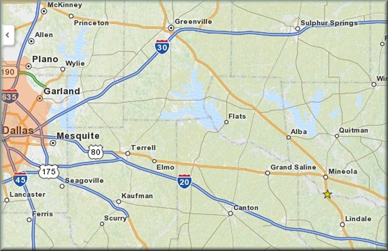 Click map for larger image      |
| * International Scale of River Difficulty
Class I: Easy. Fast moving water with riffles and small waves. Few obstructions, all obvious and easily missed with little training. Risk to swimmers is slight, self-rescue is easy.
Class II: Novice. Straightforward rapids with wide, clear channels which are evident without scouting. Occasional maneuvering may be required, but rocks and medium sized waves are easily missed by trained paddlers. Swimmers are seldom injured and group assistance, while helpful, is seldom needed. Class III: Intermediate. Rapids with moderate, irregular waves which may be difficult to avoid and which can swamp an open canoe. Complex maneuvers in fast current and good boat control in tight passages or around ledges are often required; large waves or strainers may be present but are easily avoided. Strong eddies and powerful current effects can be found, particularly on large-volume rivers. Scouting is advisable for inexperienced parties. Injuries while swimming are rare; self-rescue is usually easy but group assistance may be required to avoid long swims. Class IV: Advanced. Intense, powerful but predictable rapids requiring precise boat handling in turbulent water. Depending on the character of the river, it may feature large, unavoidable waves and holes or constricted passages demanding fast maneuvers under pressure. A fast, reliable eddy turn may be needed to initiate maneuvers, scout rapids, or rest. Rapids may require "must" moves above dangerous hazards. Scouting is necessary the first time down. Risk of injury to swimmers is moderate to high, and water conditions may make self-rescue difficult. Group assistance for rescue is often essential but requires practiced skills. A strong eskimo roll is highly recommended. Class V: Expert. Extremely long, obstructed, or very violent rapids which expose a paddler to above average endangerment. Drops may contain large, unavoidable waves and holes or steep, congested chutes with complex, demanding routes. Rapids may continue for long distances between pools, demanding a high level of fitness. What eddies exist may be small, turbulent, or difficult to reach. At the high end of the scale, several of these factors may be combined. Scouting is mandatory but often difficult. Swims are dangerous, and rescue is difficult even for experts. A very reliable eskimo roll, proper equipment, extensive experience, and practiced rescue skills are essential for survival. Class VI: Extreme. One grade more difficult than Class V. These runs often exemplify the extremes of difficulty, unpredictability and danger. The consequences of errors are very severe and rescue may be impossible. For teams of experts only, at favorable water levels, after close personal inspection and taking all precautions. This class does not represent drops thought to be unrunnable, but may include rapids which are only occasionally run. |
 Copyright © 1996-2010, Dallas Downriver Club. All rights reserved. CobraGraphics is the trademark of Marc W. McCord dba CobraGraphics. The textual, graphic, audio, and audio/visual material in this site is protected by United States copyright law and international treaties. You may not copy, distribute, or use these materials except for your personal, non-commercial use. Any trademarks are the property of their respective owners. All original photographic images are the exclusive property of Dallas Downriver Club or other designated photographers and may not be copied, duplicated, reproduced, distributed or used in any manner without prior written permission of the copyright owner under penalty of US and International laws and treaties. |